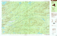
1997 Map of Wakely Mountain
USGS Topo · Published 2000About this map
Kamp Kill Kare sits near the northern shore of Lake Long Lake, a notable private landmark within the sprawling Adirondack Park. The landscape is dominated by complex water systems and high ridges, where the South Branch Moose River and Otter Brook carve through the central terrain. To the west, the Fulton Chain Lakes begin with Seventh Lake, while elevations rise sharply toward peaks like Wakely Mountain and Bradley Mtn. The 1990s layout reveals a remote interior of the North Woods, showing the intricate drainage of Mitchell Ponds, Sly Pond, and Little Moose Lake before they reach the larger river valleys. This map captures the mid-century wilderness character preserved in Arietta and Inlet, providing a clear view of the mountain passes and remote ponds that have long drawn seasonal visitors to the region.
Find a feature on this map
64 named features on this map. Tap any name to fly to it.
Don’t see what you’re looking for? This feature index may not catch every label — zoom into the map to look around manually.
Map Details
Editions of this 1997 Wakely Mountain Map
This is the sole edition of this map. No revisions or reprints were ever made.
Other maps of this area

1899 · Indian Lake
USGS Topo · 1:62,500

1900 · Canada Lake
USGS Topo · 1:62,500

1901 · Old Forge
USGS Topo · 1:62,500

1902 · Indian Lake
USGS Topo · 1:62,500

1903 · Big Moose
USGS Topo · 1:62,500

1903 · West Canada Lakes
USGS Topo · 1:62,500

1903 · Raquette Lake
USGS Topo · 1:62,500

1903 · Blue Mountain
USGS Topo · 1:62,500

1950 · Utica
USGS Topo · 1:250,000
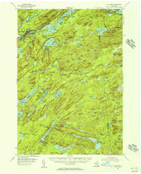
1954 · Old Forge
USGS Topo · 1:62,500