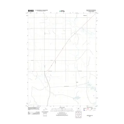
2012 Map of Wakpamani
USGS Topo · Published 2012About this map
Wakpamani and the surrounding high plains are defined by the convergence of traditional travel routes and natural water features. In the southern portion of the quadrangle, the landscape is punctuated by Wakpamani Lake, Feather on Head Lake, and Little Locke Lake, which provide critical reference points in an area characterized by wide spacing between landmarks. Family and cultural history are anchored by the Feather on Head Cem, located near the intersection of several established thoroughfares. The road network reflects layers of transportation history, from the legacy of Old Hwy 18 and Wakpamni Old Rd to the more modern New Wakpamni Road BIA. Drainage patterns across the territory are shaped by the meandering courses of Stinking Water Cr and Bartlett Cr, which dictate the placement of ranch roads and rural homesteads in this part of South Dakota.
Find a feature on this map
13 named features on this map. Tap any name to fly to it.
Don’t see what you’re looking for? This feature index may not catch every label — zoom into the map to look around manually.
Map Details
Editions of this 2012 Wakpamani Map
This is the sole edition of this map. No revisions or reprints were ever made.
Other maps of this area

1955 · Hot Springs
USGS Topo · 1:250,000

1955 · Alliance
USGS Topo · 1:250,000

1957 · Alliance
USGS Topo · 1:250,000

1958 · Alliance
USGS Topo · 1:250,000

1967 · Wounded Knee
USGS Topo · 1:24,000

1967 · Denby
USGS Topo · 1:24,000

1969 · Clinton NE
USGS Topo · 1:24,000
1969 · Hog Island
USGS Topo · 1:24,000
1969 · Gordon NW
USGS Topo · 1:24,000
1981 · Wakpamani
USGS Topo · 1:25,000