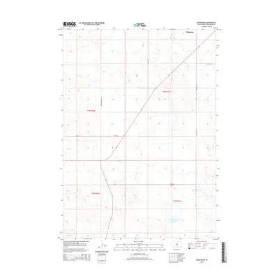
2015 Map of Wakpamani
USGS Topo · Published 2015About this map
Wakpamani and the surrounding high plains of the Pine Ridge region are defined by a network of seasonal watercourses and remote landmarks in this 2015 survey. The landscape is structured by a grid of rural routes such as Gordon Junction RD and Wakpamani Rd, which connect isolated features like Feather on Head Cem. The drainage patterns of Stinking Water Cr and Bartlett Cr cut through the terrain, leading toward local catchments including Wakpamani Lake and Feather on Head Lake. This map provides a clear view of the modern land management and transportation layout within the Oglala Lakota territory, tracing the physical relationship between family-named sites and the expansive natural drainage systems of southwestern South Dakota.
Find a feature on this map
17 named features on this map. Tap any name to fly to it.
Don’t see what you’re looking for? This feature index may not catch every label — zoom into the map to look around manually.
Map Details
Editions of this 2015 Wakpamani Map
This is the sole edition of this map. No revisions or reprints were ever made.
Other maps of this area

1955 · Hot Springs
USGS Topo · 1:250,000

1955 · Alliance
USGS Topo · 1:250,000

1957 · Alliance
USGS Topo · 1:250,000

1958 · Alliance
USGS Topo · 1:250,000

1967 · Wounded Knee
USGS Topo · 1:24,000

1967 · Denby
USGS Topo · 1:24,000

1969 · Clinton NE
USGS Topo · 1:24,000
1969 · Hog Island
USGS Topo · 1:24,000
1969 · Gordon NW
USGS Topo · 1:24,000
1981 · Wakpamani
USGS Topo · 1:25,000