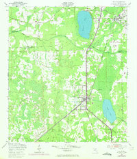
1949 Map of Waldo
USGS Topo · Published 1972About this map
Waldo serves as a critical rail junction on this mid-century survey, where the Seaboard Coast Line converges near the southern shores of Hampton Lake. The landscape is defined by its water systems and timber resources, with the Santa Fe River and the Santa Fe Canal providing drainage for the low-lying terrain. To the south, the expansive Austin Cary Forest dominates the Alachua County side of the border, marked by the Austin-Cary Monument and a network of logging tracks including the Cary Austin Forest line. Small settlements like Graham, Louise, and Shenks are scattered throughout the region, often tied to the rail corridors or local agriculture. Genealogists may find interest in the location of the Santa Fe Cem and the Frecanian Ch, while the presence of a rural Airstrip and Water Tank reflect the local infrastructure of the 1940s prior to late 20th-century development.
Find a feature on this map
21 named features on this map. Tap any name to fly to it.
Don’t see what you’re looking for? This feature index may not catch every label — zoom into the map to look around manually.
Map Details
Editions of this 1949 Waldo Map
3 editions found
Other maps of this area

1890 · Arredondo
USGS Topo · 1:62,500

1892 · Arredondo
USGS Topo · 1:62,500

1894 · Arredondo
USGS Topo · 1:62,500

1938 · Hawthorn
USGS Topo · 1:48,000

1941 · Starke
USGS Topo · 1:62,500

1943 · Hawthorn
USGS Topo · 1:62,500

1948 · Starke
USGS Topo · 1:50,000

1949 · Sampson
USGS Topo · 1:24,000

1949 · Starke
USGS Topo · 1:24,000

1949 · Waldo
USGS Topo · 1:24,000