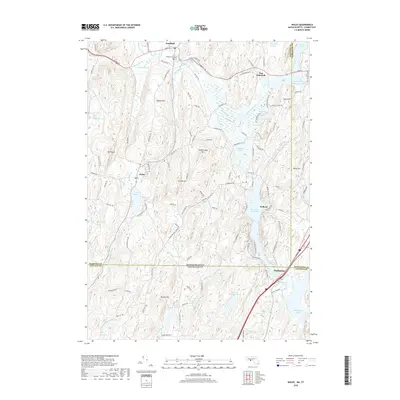
2018 Map of Wales
USGS Topo · Published 2018About this map
The Massachusetts and Connecticut border defines the geography of this area, where the town of Wales and the village of Mashapaug sit just across the state line from one another. This 2018 survey reveals a landscape heavily shaped by its water systems, from the expansive Hamilton Reservoir and East Brimfield Lake to the winding Quinebaug River. The settlement pattern follows the narrow valleys between significant peaks like Mt Pisgah and Rattlesnake Mtn, with Brimfield and Holland serving as central hubs for the surrounding highlands. Researchers of local genealogy will find the Brimfield Cem and various family-named hills, including Haynes Hill and Janes Hill, which persist as landmarks. The road network, including Stafford-Holland Rd and Ferry Tavern Rd, traces long-established routes through the marshy lowlands of Single Swamp and Sessions Meadow Marsh.
Find a feature on this map
57 named features on this map. Tap any name to fly to it.
Don’t see what you’re looking for? This feature index may not catch every label — zoom into the map to look around manually.
Map Details
Editions of this 2018 Wales Map
This is the sole edition of this map. No revisions or reprints were ever made.
Other maps of this area

1887 · Brookfield
USGS Topo · 1:62,500

1887 · Palmer
USGS Topo · 1:62,500

1889 · Palmer
USGS Topo · 1:62,500

1890 · Brookfield
USGS Topo · 1:62,500

1892 · Woodstock
USGS Topo · 1:62,500

1892 · Tolland
USGS Topo · 1:62,500

1893 · Palmer
USGS Topo · 1:62,500

1893 · Brookfield
USGS Topo · 1:62,500

1908 · Ware
USGS Topo · 1:125,000

1915 · Brookfield
USGS Topo · 1:62,500