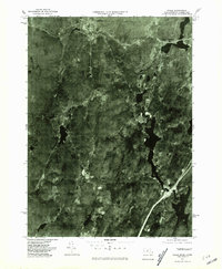
1975 Map of Wales
USGS Topo · Published 1981About this map
Wales and Holland sit at the center of this 1970s orthophotoquad, showcasing the densely wooded transition between Massachusetts and Connecticut before late-century development intensified. The aerial perspective reveals the intricate relationship between the region's topography and its water systems, most notably the long reach of the Hamilton Reservoir and the winding course of the Quinebaug River. Small settlements such as Brimfield and East Brimfield appear as clusters of activity against the heavy forest cover, while Mashapaug marks the southern extent of the survey near the state line. This photographic record, produced by the Geological Survey and the Commonwealth of Massachusetts Department of Public Works, preserves the landscape as it appeared in the autumn of 1975, capturing the exact footprint of crossroads and shoreline structures before modern expansion.
Find a feature on this map
7 named features on this map. Tap any name to fly to it.
Don’t see what you’re looking for? This feature index may not catch every label — zoom into the map to look around manually.
Map Details
Editions of this 1975 Wales Map
This is the sole edition of this map. No revisions or reprints were ever made.
Other maps of this area

1887 · Brookfield
USGS Topo · 1:62,500

1887 · Palmer
USGS Topo · 1:62,500

1889 · Palmer
USGS Topo · 1:62,500

1890 · Brookfield
USGS Topo · 1:62,500

1892 · Woodstock
USGS Topo · 1:62,500

1892 · Tolland
USGS Topo · 1:62,500

1893 · Palmer
USGS Topo · 1:62,500

1893 · Brookfield
USGS Topo · 1:62,500

1908 · Ware
USGS Topo · 1:125,000

1915 · Brookfield
USGS Topo · 1:62,500