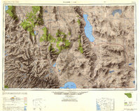
1948 Map of Walker Lake
USGS Topo · Published 1948About this map
Walker Lake and the arid Great Basin topography of Mineral and Lyon counties meet the high eastern edge of the Sierra Nevada in this late 1940s survey. The map records a landscape defined by significant water bodies, from the vast Lake Tahoe in the northwest to the saline expanse of Mono Lake and the distinctive Paoha Island. A network of mining history and high-desert settlement is evident, featuring the famous district of Bodie and the Leviathan Sulphur Mine, alongside railroad towns like Luning and Mina along the Southern Pacific line.
Find a feature on this map
94 named features on this map. Tap any name to fly to it.
Don’t see what you’re looking for? This feature index may not catch every label — zoom into the map to look around manually.
Map Details
Editions of this 1948 Walker Lake Map
2 editions found

Other maps of this area

1889 · Pyramid Peak
USGS Topo · 1:125,000

1889 · Markleeville
USGS Topo · 1:125,000

1891 · Carson
USGS Topo · 1:125,000

1891 · Markleeville
USGS Topo · 1:125,000

1891 · Truckee
USGS Topo · 1:125,000

1891 · Big Trees
USGS Topo · 1:125,000

1891 · Wabuska
USGS Topo · 1:125,000

1891 · Pyramid Peak
USGS Topo · 1:125,000

1891 · Wellington
USGS Topo · 1:125,000

1893 · Carson
USGS Topo · 1:125,000