
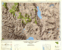
1948 Map of Walker Lake
USGS Topo · Published 1948About this map
Walker Lake serves as the focal point of this high-altitude landscape, where the Great Basin of Nevada meets the eastern slope of the Sierra Nevada mountains in California. Compiled from earlier surveys dating back to 1893 and updated with 1940s aerial photography, the map highlights the transition from agricultural valleys like Smith Valley and Minden to the high-country peaks of Yosemite National Park. The industrial footprint of the era is clearly marked by the Southern Pacific railroad line connecting settlements such as Thorne, Luning, and Mina.
Find a feature on this map
177 named features on this map. Tap any name to fly to it.
Don’t see what you’re looking for? This feature index may not catch every label — zoom into the map to look around manually.
Map Details
Editions of this 1948 Walker Lake Map
2 editions found
Other maps of this area

1889 · Pyramid Peak
USGS Topo · 1:125,000

1889 · Markleeville
USGS Topo · 1:125,000

1891 · Carson
USGS Topo · 1:125,000

1891 · Markleeville
USGS Topo · 1:125,000

1891 · Truckee
USGS Topo · 1:125,000

1891 · Big Trees
USGS Topo · 1:125,000

1891 · Wabuska
USGS Topo · 1:125,000

1891 · Pyramid Peak
USGS Topo · 1:125,000

1891 · Wellington
USGS Topo · 1:125,000

1893 · Carson
USGS Topo · 1:125,000