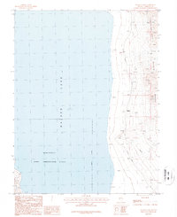
1987 Map of Walker Lake
USGS Topo · Published 1987About this map
Walker Lake dominates this Nevada landscape, where the eastern shoreline meets the rising terrain of the Gillis Range and Agai Pah Hills. During the late twentieth century, this area served as a critical corridor for military and industrial activity. The southern portion of the lake is occupied by the Hawthorne Army Ammunition Plant, a significant federal installation defined here by an Indefinite Boundary. Transportation infrastructure is concentrated along the narrow strip between the water and the mountains, featuring the Southern Pacific railroad line and several Trans Lines. Evidence of mineral exploration appears in the hills via multiple prospects and a Gravel Pit. The map also preserves the location of Magnus (Site), a former settlement point along the rail line that had largely disappeared by this era, leaving only a geographic marker on the desert floor.
Find a feature on this map
13 named features on this map. Tap any name to fly to it.
Don’t see what you’re looking for? This feature index may not catch every label — zoom into the map to look around manually.
Map Details
Editions of this 1987 Walker Lake Map
This is the sole edition of this map. No revisions or reprints were ever made.
Other maps of this area

1909 · Hawthorne
USGS Topo · 1:250,000

1911 · Hawthorne
USGS Topo · 1:250,000

1915 · Hawthorne
USGS Topo · 1:250,000

1948 · Walker Lake
USGS Topo · 1:250,000

1955 · Hawthorne
USGS Topo · 1:62,500

1956 · Mt. Grant
USGS Topo · 1:62,500

1957 · Walker Lake
USGS Topo · 1:250,000

1962 · Walker Lake
USGS Topo · 1:250,000

1964 · Walker Lake
USGS Topo · 1:250,000

1964 · Gillis Canyon
USGS Topo · 1:62,500