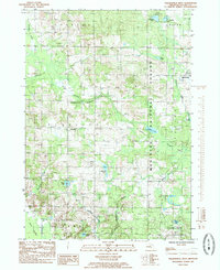
1985 Map of Walkerville West
USGS Topo · Published 1985About this map
Walkerville sits at the eastern edge of this mid-1980s landscape, where the agricultural clearings of Elbridge and Crystal townships meet the wooded expanse of the Manistee National Forest. This region of West Michigan is defined by its diverse hydrologic network, featuring the South Branch Pentwater River and a scattering of glacial basins including Pebawma Lake, Leavitt Lake, and Cobmoosa Lake. The map reveals the imprint of 19th-century infrastructure through the Old Grade trail, while smaller settlements like Routley and Twin Bridges Corners indicate local landmarks that have persisted through generations of rural life.
Find a feature on this map
32 named features on this map. Tap any name to fly to it.
Don’t see what you’re looking for? This feature index may not catch every label — zoom into the map to look around manually.
Map Details
Editions of this 1985 Walkerville West Map
This is the sole edition of this map. No revisions or reprints were ever made.
Other maps of this area

1931 · Custer SW
USGS Topo · 1:31,680

1931 · Hart SE
USGS Topo · 1:31,680

1931 · Walkerville NE
USGS Topo · 1:31,680

1931 · Hart NE
USGS Topo · 1:31,680

1931 · Walkerville SW
USGS Topo · 1:31,680

1931 · Walkerville NW
USGS Topo · 1:31,680

1931 · Custer SE
USGS Topo · 1:31,680

1931 · Walkerville SE
USGS Topo · 1:31,680

1932 · Ludington SE
USGS Topo · 1:31,680

1954 · Milwaukee
USGS Topo · 1:250,000