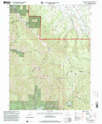
1998 Map of Wallsburg Ridge
USGS Topo · Published 2000About this map
Wallsburg Ridge dominates this late-twentieth-century landscape where the Heber Pleasant Grove Ranger District meets the Spanish Fork Ranger District. This high-elevation terrain is defined by its drainage systems, including the South Fork Provo River and various tributaries of Hobble Creek. The map documents a sophisticated network of wilderness access routes such as the Western Trail, Upper Spanish Fork Trail, and Ranger Trail, which navigate between prominent landmarks like Bald Knoll and the level expanse of Wing Flat. The presence of Mines and scattered water sources like Warm Spring suggest a history of resource extraction and seasonal grazing within the Uinta National Forest. The boundary between Wasatch and Utah Counties bisects the area, highlighting the remote, high-altitude character of the Wasatch Range transition.
Find a feature on this map
41 named features on this map. Tap any name to fly to it.
Don’t see what you’re looking for? This feature index may not catch every label — zoom into the map to look around manually.
Map Details
Editions of this 1998 Wallsburg Ridge Map
This is the sole edition of this map. No revisions or reprints were ever made.
Other maps of this area

1885 · Salt Lake
USGS Topo · 1:250,000

1907 · Strawberry Valley
USGS Topo · 1:125,000

1909 · Strawberry Valley
USGS Topo · 1:125,000

1948 · Orem
USGS Topo · 1:62,500

1948 · Springville
USGS Topo · 1:24,000

1948 · Aspen Grove
USGS Topo · 1:24,000

1948 · Bridal Veil Falls
USGS Topo · 1:24,000

1949 · Provo
USGS Topo · 1:62,500

1950 · Aspen Grove
USGS Topo · 1:24,000
1950 · Bridal Veil Falls
USGS Topo · 1:24,000