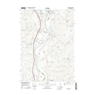
2015 Map of Walpole
USGS Topo · Published 2015About this map
The Connecticut River serves as the dividing line between New Hampshire and Vermont, carving a path through this landscape between Walpole and Westminster. The river's influence is evident in the fertile lowlands of Putney Great Meadows and Boggy Meadows, as well as the naming of Westminster Station and several river islands such as Spencer Island and Dunshee Island. This 2015 survey documents the continued use of local aviation at Frank D. Comerford Airport and Santa's Airport while showing the enduring footprint of long-established settlements at Dodge Tavern and Westmoreland Depot. Numerous burial grounds, including Westminster Old Cem and the Polish-Sacred Heart Cem, highlight the area's deep-rooted community history. The terrain is defined by prominent elevations like Hedgehog Hill and Gilboa Mtn, which overlook the diverse water network of Saxtons River and Blanchard Brook.
Find a feature on this map
144 named features on this map. Tap any name to fly to it.
Don’t see what you’re looking for? This feature index may not catch every label — zoom into the map to look around manually.
Map Details
Editions of this 2015 Walpole Map
This is the sole edition of this map. No revisions or reprints were ever made.
Other maps of this area

1891 · Brattleboro
USGS Topo · 1:62,500

1893 · Brattleboro
USGS Topo · 1:62,500

1898 · Keene
USGS Topo · 1:62,500

1927 · Bellows Falls
USGS Topo · 1:48,000

1930 · Saxtons River
USGS Topo · 1:48,000

1930 · Bellows Falls
USGS Topo · 1:62,500

1932 · Brattleboro
USGS Topo · 1:48,000

1932 · Keene
USGS Topo · 1:62,500

1933 · Saxtons River
USGS Topo · 1:62,500
1935 · Brattleboro
USGS Topo · 1:62,500