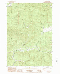
1984 Map of Walton
USGS Topo · Published 1984About this map
Walton and the surrounding Lane County hills are defined by the narrow drainage of Wildcat Creek, where the Southern Pacific railroad follows the valley floor through a landscape of timber and steep ridges. This mid-1980s provisional survey shows the settlement pattern clustered along the rail line and Route 126, including the Lyons Sch and Walton Cem. Further into the hills, the map records established sites like the Chickahominy Cem near the banks of Chickahominy Creek, a name that suggests the migration of Appalachian or Southern place-names into the Oregon Coast Range. The terrain is marked by significant peaks such as Nelson Mountain and Iron Mountain, with the railroad providing the primary industrial link between smaller localities like Globe and Pataha. Numerous named tributaries, including Haynes Creek and January Creek, drain the high ground towards the Divide, illustrating the complex hydrology of the western Cascades.
Find a feature on this map
40 named features on this map. Tap any name to fly to it.
Don’t see what you’re looking for? This feature index may not catch every label — zoom into the map to look around manually.
Map Details
Editions of this 1984 Walton Map
This is the sole edition of this map. No revisions or reprints were ever made.
Other maps of this area

1909 · Elmira
USGS Topo · 1:62,500

1922 · Elmira
USGS Topo · 1:62,500

1941 · Blachly
USGS Topo · 1:62,500

1942 · Elmira
USGS Topo · 1:62,500

1942 · Blachly
USGS Topo · 1:62,500

1942 · Crow
USGS Topo · 1:62,500

1942 · Roman Nose Mtn
USGS Topo · 1:62,500

1945 · Crow
USGS Topo · 1:62,500

1945 · Roman Nose Mtn
USGS Topo · 1:62,500

1953 · Salem
USGS Topo · 1:250,000