
1942 Map of Crow
USGS Topo · Published 1960About this map
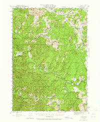
The Siuslaw River and its complex network of tributaries define this 1942 landscape in western Lane Co. The terrain is marked by small settlements and rural commerce hubs like Crow and the Wolf Creek Store, while the southern reaches follow the Smith River into Douglas Co. This area reflects a mid-century reliance on forest management and localized ranching, evidenced by the Lorane Guard Sta and the King Ranch. Educational foundations are visible at the Hadleyville Sch and Beaver Cr Sch, serving communities that were often organized around the drainage of local creeks. An Old Railroad Grade follows Douglas Creek, hinting at an earlier era of resource extraction or transportation that had already begun to shift by the time of this survey. From the high point of Roman Nose Mountain to the depths of Siuslaw Falls, the map documents a transition from the rolling hills of the Willamette Valley fringe into the more deeply dissected Coast Range.
Find a feature on this map
46 named features on this map. Tap any name to fly to it.
Don’t see what you’re looking for? This feature index may not catch every label — zoom into the map to look around manually.
Map Details
Editions of this 1942 Crow Map
2 editions found
Other maps of this area

1909 · Elmira
USGS Topo · 1:62,500

1910 · Eugene
USGS Topo · 1:62,500

1921 · Cottage Grove
USGS Topo · 1:62,500

1922 · Elmira
USGS Topo · 1:62,500

1940 · Eugene
USGS Topo · 1:62,500

1941 · Blachly
USGS Topo · 1:62,500

1942 · Elmira
USGS Topo · 1:62,500

1942 · Blachly
USGS Topo · 1:62,500

1942 · Roman Nose Mtn
USGS Topo · 1:62,500

1945 · Crow
USGS Topo · 1:62,500