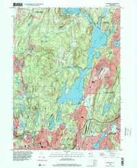
1995 Map of Wanaque
USGS Topo · Published 2000About this map
The Wanaque Reservoir dominates this landscape in the mid-1990s, its shoreline winding through a region heavily defined by conservation and protected lands. The map reveals the dense concentration of community features along the eastern and southern edges of the water, including the Eleanor Hewitt Sch and the Queen of the Rosary church. Further south, the suburban expansion of Haskell and Bloomingdale is clearly mapped, showing the transition from the wilder tracts of the Norvin Green State Forest and Ramapo Mountain State Forest into established residential neighborhoods. This survey provides an important record of the water management infrastructure that shaped the area, specifically detailing the Midvale Dam and Furnace Road Dam which control the flow into the Wanaque River. Local historians can trace the legacy of early industry at Longpond Ironworks State Park and the development of mountain communities like Stonetown.
Find a feature on this map
61 named features on this map. Tap any name to fly to it.
Don’t see what you’re looking for? This feature index may not catch every label — zoom into the map to look around manually.
Map Details
Editions of this 1995 Wanaque Map
This is the sole edition of this map. No revisions or reprints were ever made.
Other maps of this area

1888 · Morristown
USGS Topo · 1:62,500

1888 · Paterson
USGS Topo · 1:62,500

1891 · Greenwood Lake
USGS Topo · 1:62,500

1891 · Ramapo
USGS Topo · 1:62,500

1892 · Paterson
USGS Topo · 1:62,500

1893 · Greenwood Lake
USGS Topo · 1:62,500

1893 · Ramapo
USGS Topo · 1:62,500

1894 · Morristown
USGS Topo · 1:62,500

1898 · Morristown
USGS Topo · 1:62,500

1898 · Paterson
USGS Topo · 1:62,500