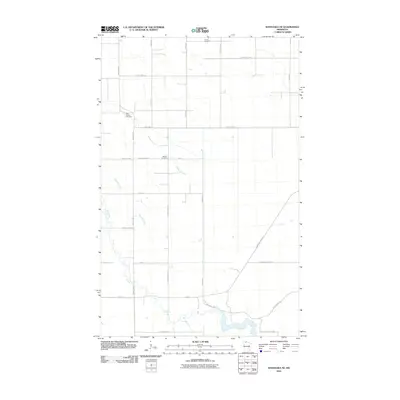
2010 Map of Wannaska NE
USGS Topo · Published 2010About this map
Falun Cemetery and Saint Phillips Cemetery sit within the rural agricultural landscape of northern Minnesota, marking the long-standing settlement of Roseau County. The terrain is defined by the winding course of the Roseau River, which meanders through the southwestern corner of the quadrangle, joined by tributaries like Severson Creek and Rafferty Creek. These waterways and the surrounding drainage patterns influenced the placement of the grid-like road network, including County Hwy-9 and County Hwy-13.
Find a feature on this map
23 named features on this map. Tap any name to fly to it.
Don’t see what you’re looking for? This feature index may not catch every label — zoom into the map to look around manually.
Map Details
Editions of this 2010 Wannaska NE Map
This is the sole edition of this map. No revisions or reprints were ever made.
Other maps of this area

1918 · Goos
USGS Topo · 1:62,500

1918 · Pencer
USGS Topo · 1:62,500

1918 · Warroad
USGS Topo · 1:62,500

1943 · Goos
USGS Topo · 1:62,500

1943 · Warroad
USGS Topo · 1:62,500

1954 · Roseau
USGS Topo · 1:250,000

1957 · Roseau
USGS Topo · 1:250,000

1958 · Roseau
USGS Topo · 1:250,000

1966 · Malung
USGS Topo · 1:24,000
1966 · Salol
USGS Topo · 1:24,000