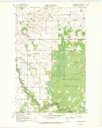
1967 Map of Wannaska NE
USGS Topo · Published 1969About this map
The Roseau River meanders through the southern portion of this landscape, its path defined by a series of engineered drainage systems including County Ditch No 21 and Severson Ditch. This 1967 survey reveals a frontier-like transition where the agricultural fields of Golden Valley and Falun meet the heavy timber of the Beltrami Island State Forest. A portion of the Red Lake Indian Reservation is visible along the eastern edge, showing the jurisdictional boundaries that defined Northern Minnesota land use during this era.
Find a feature on this map
19 named features on this map. Tap any name to fly to it.
Don’t see what you’re looking for? This feature index may not catch every label — zoom into the map to look around manually.
Map Details
Editions of this 1967 Wannaska NE Map
This is the sole edition of this map. No revisions or reprints were ever made.
Other maps of this area

1918 · Goos
USGS Topo · 1:62,500

1918 · Pencer
USGS Topo · 1:62,500

1918 · Warroad
USGS Topo · 1:62,500

1943 · Goos
USGS Topo · 1:62,500

1943 · Warroad
USGS Topo · 1:62,500

1954 · Roseau
USGS Topo · 1:250,000

1957 · Roseau
USGS Topo · 1:250,000

1958 · Roseau
USGS Topo · 1:250,000

1966 · Malung
USGS Topo · 1:24,000
1966 · Salol
USGS Topo · 1:24,000