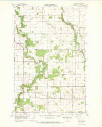
1967 Map of Wannaska
USGS Topo · Published 1969About this map
The South Fork Roseau River and the main stem of the Roseau River dominate this portion of Roseau County, carving winding paths through a landscape defined by townships like Mickinock and Grimstad. At the time of this 1967 survey, the small community of Wannaska served as a local hub near the river fork, while Pencer anchored the eastern side of the quadrangle. The map reveals the intricate water management of the region, where natural drainage from Sucker Creek and Paulson Creek is supplemented by straight-line engineering like County Ditch No 21.
Find a feature on this map
17 named features on this map. Tap any name to fly to it.
Don’t see what you’re looking for? This feature index may not catch every label — zoom into the map to look around manually.
Map Details
Editions of this 1967 Wannaska Map
This is the sole edition of this map. No revisions or reprints were ever made.
Other maps of this area

1918 · Goos
USGS Topo · 1:62,500

1918 · Pencer
USGS Topo · 1:62,500

1918 · Roseau
USGS Topo · 1:62,500

1918 · Garland
USGS Topo · 1:62,500

1943 · Goos
USGS Topo · 1:62,500

1954 · Roseau
USGS Topo · 1:250,000

1957 · Roseau
USGS Topo · 1:250,000

1958 · Roseau
USGS Topo · 1:250,000

1966 · Malung
USGS Topo · 1:24,000
1966 · Roseau
USGS Topo · 1:24,000