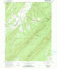
1965 Map of Wardensville
USGS Topo · Published 1990About this map
Wardensville serves as the focal point of this mid-1960s survey, situated where Trout Run and Waites Run meet the north-flowing Cacapon River. The landscape is defined by the sharp ridges of Sandy Ridge and Capon Mountain, which hem in the narrow river valleys. Within these corridors, the Reymann Memorial Farms West Virginia University and Clagett Farm represent the agricultural heritage of the region. A deeper history of industry and community is revealed through landmarks like the Old Iron Furnace in the south and small mountain churches including Crest Hill Ch and Marvin Chapel. The map provides excellent genealogical detail for the area, marking family-named sites such as Alum-Bank Cem and Wilson Cem. Much of the eastern and southern terrain is protected within the George Washington National Forest, where the Paddy Mountain Trail traverses the high ground above Vances Cove.
Find a feature on this map
53 named features on this map. Tap any name to fly to it.
Don’t see what you’re looking for? This feature index may not catch every label — zoom into the map to look around manually.
Map Details
Editions of this 1965 Wardensville Map
Other maps of this area

1891 · Romney
USGS Topo · 1:125,000

1892 · Woodstock
USGS Topo · 1:125,000

1893 · Luray
USGS Topo · 1:125,000

1894 · Winchester
USGS Topo · 1:125,000

1905 · Luray
USGS Topo · 1:125,000

1922 · Wardensville
USGS Topo · 1:62,500

1923 · Middletown
USGS Topo · 1:62,500

1923 · Edinburg
USGS Topo · 1:62,500

1924 · Wardensville
USGS Topo · 1:62,500

1937 · Middletown
USGS Topo · 1:48,000