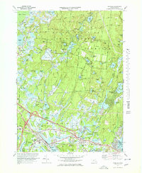
1972 Map of Wareham
USGS Topo · Published 1978About this map
Myles Standish State Forest dominates the northern reaches of this coastal landscape, where a dense network of freshwater ponds like College Pond and Fearing Pond is interspersed with an intricate system of Cranberry Bogs. This 1970s survey reveals the intense cultivation of the wetlands surrounding Tihonet Pond and Maple Swamp, illustrating the area's specialized agricultural history. To the south, the settlement of Wareham clusters along the waterways, showing the rail infrastructure of the Penn Central and the transition from inland forests to the tidal influence of Miller Cove. The map details the residential growth at White Island Shores and Oakdale, providing a clear record of the region's mid-century development. Genealogy researchers can locate family sites near Centre Cem and St Patricks Cem, or trace the old roads leading to South Carver through the pine barrens.
Find a feature on this map
124 named features on this map. Tap any name to fly to it.
Don’t see what you’re looking for? This feature index may not catch every label — zoom into the map to look around manually.
Map Details
Editions of this 1972 Wareham Map
3 editions found
Other maps of this area

1885 · New Bedford
USGS Topo · 1:62,500

1885 · Middleboro
USGS Topo · 1:62,500

1886 · Falmouth
USGS Topo · 1:62,500

1886 · Plymouth
USGS Topo · 1:62,500

1888 · New Bedford
USGS Topo · 1:62,500

1888 · Falmouth
USGS Topo · 1:62,500

1888 · Middleboro
USGS Topo · 1:62,500

1889 · Plymouth
USGS Topo · 1:62,500

1893 · Middleboro
USGS Topo · 1:62,500

1893 · Falmouth
USGS Topo · 1:62,500