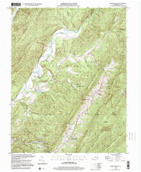
1999 Map of Warm Springs
USGS Topo · Published 2000About this map
Warm Springs Valley serves as the central corridor for this Bath County landscape, where the historic resort communities of Warm Springs and Hot Springs anchor the local geography. The map documents the concentrated settlement patterns along the valley floor, including West Warm Springs, Mitchelltown, and the company town of Bacova near its namesake Lake Bacova. These towns are interconnected by a network of local roads and the Chesapeake and Ohio rail line, which follows the orientation of the surrounding ridges. Higher elevations are dominated by the George Washington National Forest, encompassing Katydid Mountain and Cobbler Mountain. Small rural landmarks such as John Wesley Ch, Mt Hope Ch, and Valley High Sch provide essential points of reference for genealogists tracing family locations in this mountainous region during the late twentieth century.
Find a feature on this map
48 named features on this map. Tap any name to fly to it.
Don’t see what you’re looking for? This feature index may not catch every label — zoom into the map to look around manually.
Map Details
Editions of this 1999 Warm Springs Map
This is the sole edition of this map. No revisions or reprints were ever made.
Other maps of this area

1894 · Natural Bridge
USGS Topo · 1:125,000

1901 · Monterey
USGS Topo · 1:125,000

1923 · Warm Springs
USGS Topo · 1:48,000

1926 · Warm Springs
USGS Topo · 1:62,500

1929 · Falling Spring
USGS Topo · 1:24,000

1930 · Warm Springs Run
USGS Topo · 1:24,000

1930 · Mountain Grove
USGS Topo · 1:24,000

1931 · Healing Springs
USGS Topo · 1:24,000

1932 · Falling Spring
USGS Topo · 1:31,680

1933 · Mountain Grove
USGS Topo · 1:31,680