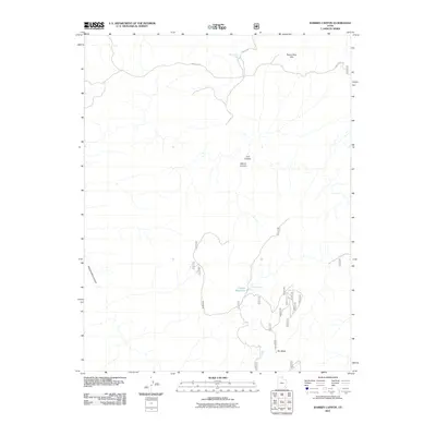
2011 Map of Warren Canyon
USGS Topo · Published 2011About this map
Sweet Alice Spring serves as a vital water point in this high-elevation landscape of San Juan County, where drainage networks define the topography. The terrain is dominated by significant erosional features such as Warren Canyon and Trail Canyon, which cut through the uplifted geography south of the Sweet Alice Hills. Towards the southern portion of the quadrangle, the land levels out onto Dry Mesa, a broad plateau that stands in contrast to the deep incisions of Woodenshoe Canyon. Human modification of this arid environment is evident in the presence of the Cooper Reservoir, fed by Cooper Spring. This 2011 survey documents a network of primitive routes and forest service roads, including the aptly named Right Leg and Sweet Alice Rd, which provide access through the remote canyon country.
Find a feature on this map
24 named features on this map. Tap any name to fly to it.
Don’t see what you’re looking for? This feature index may not catch every label — zoom into the map to look around manually.
Map Details
Editions of this 2011 Warren Canyon Map
This is the sole edition of this map. No revisions or reprints were ever made.
Other maps of this area

1886 · Henry Mountains
USGS Topo · 1:250,000

1886 · Abajo
USGS Topo · 1:250,000

1892 · Abajo
USGS Topo · 1:250,000

1892 · Henry Mountains
USGS Topo · 1:250,000

1893 · Abajo
USGS Topo · 1:250,000

1935 · Elk Ridge
USGS Topo · 1:96,000

1940 · Elk Ridge
USGS Topo · 1:125,000

1952 · Mouth of Dark Canyon
USGS Topo · 1:62,500

1952 · Natural Bridges
USGS Topo · 1:62,500
1954 · White Canyon 1 NE
USGS Topo · 1:24,000