
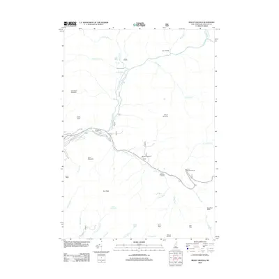
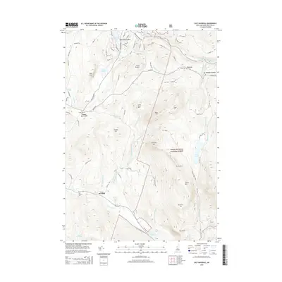
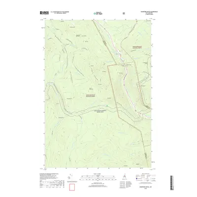
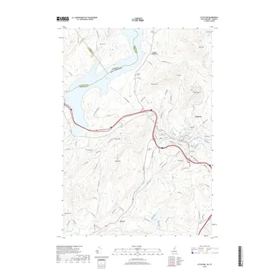
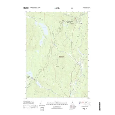
1995 Map of Warren
USGS Topo · Published 2001About this map
The Baker River carves through the central corridor of this mountain landscape, providing a focus for the village of Warren and the nearby State Fish Hatchery. The 1995 revision emphasizes the established boundaries of the White Mountain National Forest and Piermont State Forest, which dominate the rugged elevation of Webster Slide Mountain and Sentinel Mountain. The terrain is characterized by a series of high ponds and lakes, including Lake Tarleton and Upper Baker Pond, which have long served as sites for seasonal residency as seen at Moosilauke Camp and Merriwood Camp.
Find a feature on this map
58 named features on this map. Tap any name to fly to it.
Don’t see what you’re looking for? This feature index may not catch every label — zoom into the map to look around manually.
Map Details
Editions of this 1995 Warren Map
This is the sole edition of this map. No revisions or reprints were ever made.
Historical Maps of Haverhill Through Time
245 maps found

1895 Crawford Notch
Grafton County, NH

1896 Crawford Notch
Grafton County, NH

1927 Cardigan
Grafton County, NH

1927 Mascoma
Grafton County, NH

1928 Plymouth
Grafton County, NH

1928 Rumney
Grafton County, NH

1929 Franconia
Grafton County, NH

1929 Moosilauke
Grafton County, NH

1930 Cardigan
Grafton County, NH

1931 Mt. Cube
Grafton County, NH

1931 Plymouth
Grafton County, NH

1932 Franconia
Grafton County, NH

1932 Mascoma
Grafton County, NH

1932 Moosilauke
Grafton County, NH

1932 Rumney
Grafton County, NH

1933 Mt. Cube
Grafton County, NH

1946 Crawford Notch
Grafton County, NH

1950 Crawford Notch
Grafton County, NH

1956 Cardigan
Grafton County, NH

1959 Hanover
Grafton County, NH

1967 East Haverhill
Grafton County, NH

1967 Franconia
Grafton County, NH

1967 Lincoln
Grafton County, NH

1967 Lisbon
Grafton County, NH

1967 Lower Waterford
Grafton County, NH

1967 Mount Osceola
Grafton County, NH

1967 Mt. Moosilauke
Grafton County, NH

1967 South Twin Mtn
Grafton County, NH

1967 Sugar Hill
Grafton County, NH

1971 Littleton
Grafton County, NH

1973 Mount Kineo
Grafton County, NH

1973 Newbury
Grafton County, NH

1973 Rumney
Grafton County, NH

1973 Warren
Grafton County, NH

1974 Wentworth
Grafton County, NH

1979 Piermont
Grafton County, NH

1979 Smarts Mountain
Grafton County, NH

1980 Plymouth
Grafton County, NH

1980 Squam Mountains
Grafton County, NH

1980 Waterville Valley
Grafton County, NH

1980 Woodstock
Grafton County, NH

1981 Lyme
Grafton County, NH

1984 Canaan
Grafton County, NH

1984 Enfield Center
Grafton County, NH

1986 Lake Winnipesaukee
Grafton County, NH

1986 Mount Washington
Grafton County, NH

1987 Ashland
Grafton County, NH

1987 Crawford Notch
Grafton County, NH

1987 Grafton
Grafton County, NH

1987 Mount Carrigain
Grafton County, NH

1987 Mount Tripyramid
Grafton County, NH

1987 Mt. Cardigan
Grafton County, NH

1987 Newfound Lake
Grafton County, NH

1988 Mount Washington
Grafton County, NH

1995 Bethlehem
Grafton County, NH

1995 Canaan
Grafton County, NH

1995 Crawford Notch
Grafton County, NH

1995 East Haverhill
Grafton County, NH

1995 Franconia
Grafton County, NH

1995 Lincoln
Grafton County, NH

1995 Lisbon
Grafton County, NH

1995 Mount Carrigain
Grafton County, NH

1995 Mount Kineo
Grafton County, NH

1995 Mount Moosilauke
Grafton County, NH

1995 Mount Osceola
Grafton County, NH

1995 Mount Tripyramid
Grafton County, NH

1995 Plymouth
Grafton County, NH

1995 Rumney
Grafton County, NH

1995 South Twin Mountain
Grafton County, NH

1995 Squam Mountains
Grafton County, NH

1995 Sugar Hill
Grafton County, NH
1995 Warren
Grafton County, NH

1995 Waterville Valley
Grafton County, NH

1995 Wentworth
Grafton County, NH

1995 Woodstock
Grafton County, NH

1996 Enfield
Grafton County, NH

1996 Hanover
Grafton County, NH

1996 Lyme
Grafton County, NH

1996 Piermont
Grafton County, NH

1996 Smarts Mountain
Grafton County, NH

1998 Enfield Center
Grafton County, NH

1998 Mt. Cardigan
Grafton County, NH

1998 Newfound Lake
Grafton County, NH

2000 Ashland
Grafton County, NH

2012 Ashland
Grafton County, NH

2012 Bethlehem
Grafton County, NH

2012 Canaan
Grafton County, NH

2012 Crawford Notch
Grafton County, NH

2012 East Haverhill
Grafton County, NH

2012 Enfield Center
Grafton County, NH

2012 Enfield
Grafton County, NH

2012 Franconia
Grafton County, NH

2012 Grafton
Grafton County, NH

2012 Hanover
Grafton County, NH

2012 Lincoln
Grafton County, NH

2012 Lisbon
Grafton County, NH

2012 Littleton
Grafton County, NH

2012 Lyme
Grafton County, NH

2012 Mount Cardigan
Grafton County, NH

2012 Mount Carrigain
Grafton County, NH

2012 Mount Kineo
Grafton County, NH

2012 Mount Moosilauke
Grafton County, NH
2012 Mount Osceola
Grafton County, NH

2012 Mount Tripyramid
Grafton County, NH

2012 Newfound Lake
Grafton County, NH

2012 Piermont
Grafton County, NH

2012 Plymouth
Grafton County, NH

2012 Rumney
Grafton County, NH

2012 Smarts Mountain
Grafton County, NH
2012 South Twin Mountain
Grafton County, NH

2012 Squam Mountains
Grafton County, NH

2012 Sugar Hill
Grafton County, NH
2012 Warren
Grafton County, NH

2012 Waterville Valley
Grafton County, NH

2012 Wentworth
Grafton County, NH

2012 Woodstock
Grafton County, NH

2015 Ashland
Grafton County, NH

2015 Bethlehem
Grafton County, NH

2015 Canaan
Grafton County, NH
2015 Crawford Notch
Grafton County, NH
2015 East Haverhill
Grafton County, NH

2015 Enfield Center
Grafton County, NH

2015 Enfield
Grafton County, NH

2015 Franconia
Grafton County, NH

2015 Grafton
Grafton County, NH

2015 Hanover
Grafton County, NH

2015 Lincoln
Grafton County, NH

2015 Lisbon
Grafton County, NH

2015 Littleton
Grafton County, NH

2015 Lyme
Grafton County, NH

2015 Mount Cardigan
Grafton County, NH

2015 Mount Carrigain
Grafton County, NH

2015 Mount Kineo
Grafton County, NH

2015 Mount Moosilauke
Grafton County, NH
2015 Mount Osceola
Grafton County, NH

2015 Mount Tripyramid
Grafton County, NH

2015 Newfound Lake
Grafton County, NH

2015 Piermont
Grafton County, NH

2015 Plymouth
Grafton County, NH

2015 Rumney
Grafton County, NH

2015 Smarts Mountain
Grafton County, NH
2015 South Twin Mountain
Grafton County, NH

2015 Squam Mountains
Grafton County, NH

2015 Sugar Hill
Grafton County, NH
2015 Warren
Grafton County, NH

2015 Waterville Valley
Grafton County, NH

2015 Wentworth
Grafton County, NH

2015 Woodstock
Grafton County, NH

2018 Ashland
Grafton County, NH

2018 Bethlehem
Grafton County, NH

2018 Canaan
Grafton County, NH
2018 Crawford Notch
Grafton County, NH
2018 East Haverhill
Grafton County, NH

2018 Enfield Center
Grafton County, NH

2018 Enfield
Grafton County, NH
2018 Franconia
Grafton County, NH

2018 Grafton
Grafton County, NH

2018 Hanover
Grafton County, NH

2018 Lincoln
Grafton County, NH
2018 Lisbon
Grafton County, NH
2018 Littleton
Grafton County, NH

2018 Lyme
Grafton County, NH

2018 Mount Cardigan
Grafton County, NH

2018 Mount Carrigain
Grafton County, NH

2018 Mount Kineo
Grafton County, NH

2018 Mount Moosilauke
Grafton County, NH
2018 Mount Osceola
Grafton County, NH

2018 Mount Tripyramid
Grafton County, NH

2018 Newfound Lake
Grafton County, NH

2018 Piermont
Grafton County, NH

2018 Plymouth
Grafton County, NH

2018 Rumney
Grafton County, NH

2018 Smarts Mountain
Grafton County, NH
2018 South Twin Mountain
Grafton County, NH

2018 Squam Mountains
Grafton County, NH
2018 Sugar Hill
Grafton County, NH
2018 Warren
Grafton County, NH

2018 Waterville Valley
Grafton County, NH
2018 Wentworth
Grafton County, NH

2018 Woodstock
Grafton County, NH

2021 Ashland
Grafton County, NH

2021 Bethlehem
Grafton County, NH

2021 Canaan
Grafton County, NH

2021 Crawford Notch
Grafton County, NH

2021 East Haverhill
Grafton County, NH

2021 Enfield Center
Grafton County, NH

2021 Enfield
Grafton County, NH

2021 Franconia
Grafton County, NH

2021 Grafton
Grafton County, NH

2021 Hanover
Grafton County, NH

2021 Lincoln
Grafton County, NH

2021 Lisbon
Grafton County, NH

2021 Littleton
Grafton County, NH

2021 Lyme
Grafton County, NH

2021 Mount Cardigan
Grafton County, NH

2021 Mount Carrigain
Grafton County, NH

2021 Mount Kineo
Grafton County, NH

2021 Mount Moosilauke
Grafton County, NH

2021 Mount Osceola
Grafton County, NH

2021 Mount Tripyramid
Grafton County, NH

2021 Newfound Lake
Grafton County, NH

2021 Piermont
Grafton County, NH

2021 Plymouth
Grafton County, NH

2021 Rumney
Grafton County, NH

2021 Smarts Mountain
Grafton County, NH

2021 South Twin Mountain
Grafton County, NH

2021 Squam Mountains
Grafton County, NH
2021 Sugar Hill
Grafton County, NH

2021 Warren
Grafton County, NH

2021 Waterville Valley
Grafton County, NH

2021 Wentworth
Grafton County, NH

2021 Woodstock
Grafton County, NH

2023 Squam Mountains
Grafton County, NH

2024 Ashland
Grafton County, NH

2024 Bethlehem
Grafton County, NH

2024 Canaan
Grafton County, NH

2024 Crawford Notch
Grafton County, NH

2024 East Haverhill
Grafton County, NH

2024 Enfield Center
Grafton County, NH

2024 Enfield
Grafton County, NH

2024 Franconia
Grafton County, NH

2024 Grafton
Grafton County, NH

2024 Hanover
Grafton County, NH

2024 Lincoln
Grafton County, NH

2024 Lisbon
Grafton County, NH

2024 Littleton
Grafton County, NH

2024 Lyme
Grafton County, NH

2024 Mount Cardigan
Grafton County, NH

2024 Mount Carrigain
Grafton County, NH

2024 Mount Kineo
Grafton County, NH

2024 Mount Moosilauke
Grafton County, NH

2024 Mount Osceola
Grafton County, NH

2024 Mount Tripyramid
Grafton County, NH

2024 Newfound Lake
Grafton County, NH

2024 Piermont
Grafton County, NH

2024 Plymouth
Grafton County, NH

2024 Rumney
Grafton County, NH

2024 Smarts Mountain
Grafton County, NH

2024 South Twin Mountain
Grafton County, NH

2024 Squam Mountains
Grafton County, NH

2024 Sugar Hill
Grafton County, NH

2024 Warren
Grafton County, NH

2024 Waterville Valley
Grafton County, NH

2024 Wentworth
Grafton County, NH

2024 Woodstock
Grafton County, NH