
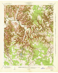
1936 Map of Wartrace
USGS Topo · Published 1936About this map
The Nashville Chattanooga and St Louis railway serves as the backbone of this 1936 Bedford County landscape, connecting the prominent rail towns of Bell Buckle and Wartrace. These settlements are hubs of activity, featuring visible infrastructure like a Water Tank and the well-known Webb Sch. Beyond the rails, the terrain is defined by the winding waters of Garrison Fork and Wartrace Creek, where smaller communities like Fairfield and Kellartown are established. This map is particularly dense with genealogical data, documenting numerous family landmarks including the Hazel Cem, Old Salem Cem, and Hollywood Cem. The presence of several transmission lines, including the State Membership Corp Transmission Line, signals the arrival of the Tennessee Valley Authority's modernization efforts in rural middle Tennessee during the mid-1930s.
Find a feature on this map
45 named features on this map. Tap any name to fly to it.
Don’t see what you’re looking for? This feature index may not catch every label — zoom into the map to look around manually.
Map Details
Editions of this 1936 Wartrace Map
This is the sole edition of this map. No revisions or reprints were ever made.
Other maps of this area

1913 · Hollow Springs
USGS Topo · 1:62,500

1936 · Ovoca
USGS Topo · 1:24,000

1936 · Webbs Jungle
USGS Topo · 1:24,000

1936 · Shelbyville
USGS Topo · 1:24,000

1936 · Deason
USGS Topo · 1:24,000

1936 · Beech Grove
USGS Topo · 1:24,000

1936 · Noah
USGS Topo · 1:24,000

1936 · Normandy
USGS Topo · 1:24,000

1936 · Fosterville
USGS Topo · 1:24,000
1941 · Ovoca
USGS Topo · 1:24,000