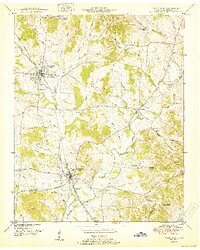
1951 Map of Wartrace
USGS Topo · Published 1951About this map
Bell Buckle and Wartrace anchor this Bedford County landscape, serving as key rail hubs for the Nashville Chattanooga and St Louis line. The map highlights the educational roots of the region at the Webb School, while the surrounding countryside is defined by a dense network of family-named burial grounds including Hazel, Cortner, and Arnold cemeteries. The topography is shaped by the winding Garrison Fork and its tributaries, which carve through the terrain near Horse Mountain. The settlement pattern follows both the rail corridors and established routes like Fairfield Pike, connecting rural outposts such as Fairfield and the curiously named Bugscuffle. Remote areas like Hatchett Hollow and Justice Hollow reveal the localized geography of the early 1950s, providing a clear record of Bedford County's rural structure.
Find a feature on this map
49 named features on this map. Tap any name to fly to it.
Don’t see what you’re looking for? This feature index may not catch every label — zoom into the map to look around manually.
Map Details
Editions of this 1951 Wartrace Map
This is the sole edition of this map. No revisions or reprints were ever made.
Other maps of this area

1913 · Hollow Springs
USGS Topo · 1:62,500

1936 · Ovoca
USGS Topo · 1:24,000

1936 · Webbs Jungle
USGS Topo · 1:24,000

1936 · Shelbyville
USGS Topo · 1:24,000

1936 · Deason
USGS Topo · 1:24,000

1936 · Beech Grove
USGS Topo · 1:24,000

1936 · Noah
USGS Topo · 1:24,000

1936 · Wartrace
USGS Topo · 1:24,000

1936 · Normandy
USGS Topo · 1:24,000

1936 · Fosterville
USGS Topo · 1:24,000