
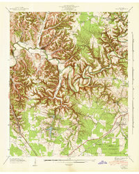
1936 Map of Noah
USGS Topo · Published 1936About this map
Noah and the surrounding rural communities of Coffee County are documented here during the mid-1930s, showing a landscape defined by ridges and narrow creek valleys. The settlement pattern follows the drainage of the Noah Fork and Garrison Fork, where schools like Farrar Hill Sch and Hurricane Sch served scattered farmsteads. This survey captures a moment when the Tennessee Valley Authority was actively mapping the region's topography, noting the path of U S Highway No 41 and early infrastructure like Electric Power Transmission Line No 2.
Find a feature on this map
75 named features on this map. Tap any name to fly to it.
Don’t see what you’re looking for? This feature index may not catch every label — zoom into the map to look around manually.
Map Details
Editions of this 1936 Noah Map
This is the sole edition of this map. No revisions or reprints were ever made.
Other maps of this area

1913 · Hollow Springs
USGS Topo · 1:62,500

1936 · Ovoca
USGS Topo · 1:24,000

1936 · Webbs Jungle
USGS Topo · 1:24,000

1936 · Fredonia
USGS Topo · 1:24,000

1936 · Manchester
USGS Topo · 1:24,000

1936 · Beech Grove
USGS Topo · 1:24,000

1936 · Petty Gap
USGS Topo · 1:24,000

1936 · Wartrace
USGS Topo · 1:24,000

1936 · Normandy
USGS Topo · 1:24,000
1941 · Ovoca
USGS Topo · 1:24,000