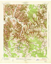
1941 Map of Ovoca
USGS Topo · Published 1943About this map
Ovoca Orphans Home and the adjacent Ovoca Lake sit at the heart of this 1941 Tennessee Valley Authority and War Department survey. The landscape is defined by the winding course of the Duck River, which is flanked by numerous family-named river crossings including Beckman Ford, Bluff Ford, and Richardson Ford. To the south, the expansion of the Camp Forrest Military Reservation begins to dominate the terrain, its Reservation Boundary encroaching upon established rural communities. This transition from a series of agrarian hamlets—marked by schools like Fourth Model Sch and Fairview Sch—to a militarized landscape is a primary feature of the era. The southeastern corner shows the Nashville Chattanooga and St Louis Railroad corridor serving Hickerson Station and New Antwerp, providing a window into the regional transportation network just before the height of World War II.
Find a feature on this map
72 named features on this map. Tap any name to fly to it.
Don’t see what you’re looking for? This feature index may not catch every label — zoom into the map to look around manually.
Map Details
Editions of this 1941 Ovoca Map
2 editions found
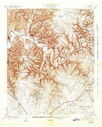
Other maps of this area

1913 · Hollow Springs
USGS Topo · 1:62,500

1936 · Ovoca
USGS Topo · 1:24,000

1936 · Fredonia
USGS Topo · 1:24,000

1936 · Manchester
USGS Topo · 1:24,000

1936 · Cumberland Springs
USGS Topo · 1:24,000

1936 · Noah
USGS Topo · 1:24,000

1936 · Wartrace
USGS Topo · 1:24,000

1936 · Camp Peay
USGS Topo · 1:24,000

1936 · Capitol Hill
USGS Topo · 1:24,000

1936 · Normandy
USGS Topo · 1:24,000