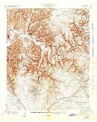
1941 Map of Ovoca
USGS Topo · Published 1943About this map
Camp Forrest Military Reservation occupies the southern reaches of this Coffee County landscape, established during the military expansion of the early 1940s. The northern territory is dominated by the winding Duck River, where numerous river crossings like Bashaw Ford, Sugarcamp Ford, and Richardson Ford highlight the rural transport network before modern bridging. The presence of the Ovoca Orphans Home near the scenic Rutledge Falls and Ovoca Lake provides a unique genealogical focal point, marking a significant local institution of the era.
Find a feature on this map
67 named features on this map. Tap any name to fly to it.
Don’t see what you’re looking for? This feature index may not catch every label — zoom into the map to look around manually.
Map Details
Editions of this 1941 Ovoca Map
2 editions found
Other maps of this area

1913 · Hollow Springs
USGS Topo · 1:62,500

1936 · Ovoca
USGS Topo · 1:24,000

1936 · Fredonia
USGS Topo · 1:24,000

1936 · Manchester
USGS Topo · 1:24,000

1936 · Cumberland Springs
USGS Topo · 1:24,000

1936 · Noah
USGS Topo · 1:24,000

1936 · Wartrace
USGS Topo · 1:24,000

1936 · Camp Peay
USGS Topo · 1:24,000

1936 · Capitol Hill
USGS Topo · 1:24,000

1936 · Normandy
USGS Topo · 1:24,000