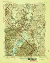
1945 Map of Washington East
USGS Topo · Published 1945About this map
The Anacostia River and its complex network of tributaries, including Paint Branch and Northwest Branch, define the landscape between the District of Columbia and Prince George's County. During this mid-1940s revision, the area shows a dense concentration of educational and civic institutions. The sprawling campus of the University of Maryland dominates the northern reaches, while the National Arboretum and Aquatic Gardens border the river to the south. Transportation is anchored by the Baltimore and Ohio RR and Pennsylvania RR, which serve established communities like Hyattsville, Riverdale, and College Park. The map captures an era of significant suburban expansion, evidenced by numerous planned settlements such as Queens Chapel Manor and Green Meadows. Cultural and religious landmarks are prominent throughout, from the Franciscan Monastery in Brookland to the historic Congressional Cem near the Sousa Bridge.
Find a feature on this map
146 named features on this map. Tap any name to fly to it.
Don’t see what you’re looking for? This feature index may not catch every label — zoom into the map to look around manually.
Map Details
Editions of this 1945 Washington East Map
This is the sole edition of this map. No revisions or reprints were ever made.
Other maps of this area

1890 · Mt. Vernon
USGS Topo · 1:125,000

1891 · Mt. Vernon
USGS Topo · 1:125,000

1892 · Laurel
USGS Topo · 1:62,500

1893 · Frederick
USGS Topo · 1:125,000

1894 · Laurel
USGS Topo · 1:62,500

1894 · Frederick
USGS Topo · 1:125,000

1894 · Mt. Vernon
USGS Topo · 1:125,000

1897 · Laurel
USGS Topo · 1:62,500

1897 · Mt. Vernon
USGS Topo · 1:125,000

1899 · Patuxent
USGS Topo · 1:125,000