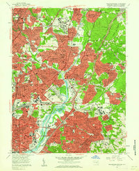
1957 Map of Washington East
USGS Topo · Published 1962About this map
The Anacostia River serves as the central artery for this mid-century survey, dividing the dense urban expansion of the District of Columbia from the burgeoning suburbs of Prince George's County. In the northeast, the College Park Airport stands as a focal point of early aviation history, while further east lies the Schrom Airport, already noted as out of use by the late 1950s. The map illustrates a landscape transitioning from institutional grounds and recreation to residential density, featuring landmarks like the National Arboretum and the Kenilworth Aquatic Gardens. Substantial cemetery tracts, including Mt Olivet Cemetery and Fort Lincoln Cemetery, occupy large segments of the terrain alongside established religious and educational institutions such as the Franciscan Monastery and Gallaudet College. Significant transportation corridors, including the B & O RR and the Baltimore-Washington Pkwy, highlight the connectivity driving the growth of communities like Hyattsville, Takoma Park, and Mount Rainier during this era of post-war suburbanization.
Find a feature on this map
256 named features on this map. Tap any name to fly to it.
Don’t see what you’re looking for? This feature index may not catch every label — zoom into the map to look around manually.
Map Details
Editions of this 1957 Washington East Map
This is the sole edition of this map. No revisions or reprints were ever made.
Other maps of this area

1890 · Mt. Vernon
USGS Topo · 1:125,000

1891 · Mt. Vernon
USGS Topo · 1:125,000

1892 · Laurel
USGS Topo · 1:62,500

1893 · Frederick
USGS Topo · 1:125,000

1894 · Laurel
USGS Topo · 1:62,500

1894 · Frederick
USGS Topo · 1:125,000

1894 · Mt. Vernon
USGS Topo · 1:125,000

1897 · Laurel
USGS Topo · 1:62,500

1897 · Mt. Vernon
USGS Topo · 1:125,000

1899 · Patuxent
USGS Topo · 1:125,000