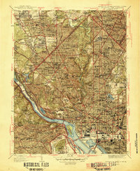
1945 Map of Washington West
USGS Topo · Published 1945About this map
Arlington National Cemetery and the monumental core of the nation's capital define this mid-century portrait of a rapidly expanding metropolitan area. The landscape is a mix of dense urban development and the strategic defensive rings of the Civil War era, preserved as parkland at Fort Stevens, Fort De Russey, and Fort Reno. The transit network is in a state of transition, showing the C & O Canal (Abandoned) alongside the active Baltimore and Ohio RR and an intricate web of avenues like Massachusetts Ave and Wisconsin Ave that spurred growth in neighborhoods such as Cleveland Park and Chevy Chase.
Find a feature on this map
166 named features on this map. Tap any name to fly to it.
Don’t see what you’re looking for? This feature index may not catch every label — zoom into the map to look around manually.
Map Details
Editions of this 1945 Washington West Map
This is the sole edition of this map. No revisions or reprints were ever made.
Other maps of this area

1890 · Mt. Vernon
USGS Topo · 1:125,000

1891 · Mt. Vernon
USGS Topo · 1:125,000

1892 · Laurel
USGS Topo · 1:62,500

1893 · Frederick
USGS Topo · 1:125,000

1894 · Laurel
USGS Topo · 1:62,500

1894 · Frederick
USGS Topo · 1:125,000

1894 · Mt. Vernon
USGS Topo · 1:125,000

1897 · Laurel
USGS Topo · 1:62,500

1897 · Mt. Vernon
USGS Topo · 1:125,000

1899 · Patuxent
USGS Topo · 1:125,000