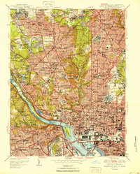
1951 Map of Washington West
USGS Topo · Published 1951About this map
The White House and the Capitol anchor this mid-century portrait of the nation's capital, showing a city in the midst of its post-war expansion. The dense urban corridors of Georgetown and Petworth contrast with the emerging suburban character of neighborhoods like Chevy Chase and Silver Spring across the Maryland line. In Virginia, the street grids of Clarendon and Cherrydale indicate the rapid growth of Arlington County.
Find a feature on this map
136 named features on this map. Tap any name to fly to it.
Don’t see what you’re looking for? This feature index may not catch every label — zoom into the map to look around manually.
Map Details
Editions of this 1951 Washington West Map
This is the sole edition of this map. No revisions or reprints were ever made.
Other maps of this area

1890 · Mt. Vernon
USGS Topo · 1:125,000

1891 · Mt. Vernon
USGS Topo · 1:125,000

1892 · Laurel
USGS Topo · 1:62,500

1893 · Frederick
USGS Topo · 1:125,000

1894 · Laurel
USGS Topo · 1:62,500

1894 · Frederick
USGS Topo · 1:125,000

1894 · Mt. Vernon
USGS Topo · 1:125,000

1897 · Laurel
USGS Topo · 1:62,500

1897 · Mt. Vernon
USGS Topo · 1:125,000

1899 · Patuxent
USGS Topo · 1:125,000