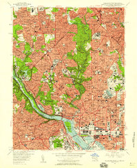
1956 Map of Washington West
USGS Topo · Published 1958About this map
Washington Cathedral and the Naval Observatory stand as prominent landmarks in this mid-century survey of the nation's capital. The map captures the dense urban core and expanding suburban neighborhoods during a period of significant post-war growth. To the west, residential developments like Bradley Hills, Kenwood, and Palisades line the banks of the Potomac River, while the heart of the District remains defined by the White House, the U S Capitol, and the Smithsonian Institution.
Find a feature on this map
222 named features on this map. Tap any name to fly to it.
Don’t see what you’re looking for? This feature index may not catch every label — zoom into the map to look around manually.
Map Details
Editions of this 1956 Washington West Map
This is the sole edition of this map. No revisions or reprints were ever made.
Other maps of this area

1890 · Mt. Vernon
USGS Topo · 1:125,000

1891 · Mt. Vernon
USGS Topo · 1:125,000

1892 · Laurel
USGS Topo · 1:62,500

1893 · Frederick
USGS Topo · 1:125,000

1894 · Laurel
USGS Topo · 1:62,500

1894 · Frederick
USGS Topo · 1:125,000

1894 · Mt. Vernon
USGS Topo · 1:125,000

1897 · Laurel
USGS Topo · 1:62,500

1897 · Mt. Vernon
USGS Topo · 1:125,000

1899 · Patuxent
USGS Topo · 1:125,000