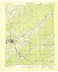
1935 Map of Watauga Valley
USGS Topo · Published 1935About this map
Elizabethton serves as the industrial and population hub of this 1930s landscape, situated at the confluence of the Watauga River and the Doe River. The surrounding terrain is defined by the heavy presence of the Cherokee National Forest, with significant mountain ranges such as Holston Mountain and the Iron Mountains constraining development to the river valleys. Evidence of the region's extractive economy is visible through landmarks like the Manganese Mine near Hampton and the Hodge Ore Bank.
Find a feature on this map
68 named features on this map. Tap any name to fly to it.
Don’t see what you’re looking for? This feature index may not catch every label — zoom into the map to look around manually.
Map Details
Editions of this 1935 Watauga Valley Map
This is the sole edition of this map. No revisions or reprints were ever made.
Other maps of this area

1891 · Roan Mountain
USGS Topo · 1:125,000

1891 · Abingdon
USGS Topo · 1:125,000

1893 · Cranberry
USGS Topo · 1:125,000

1894 · Roan Mountain
USGS Topo · 1:125,000

1894 · Abingdon
USGS Topo · 1:125,000

1895 · Cranberry
USGS Topo · 1:125,000

1897 · Bristol
USGS Topo · 1:125,000

1899 · Cranberry
USGS Topo · 1:125,000

1902 · Bristol
USGS Topo · 1:125,000

1902 · Cranberry
USGS Topo · 1:125,000