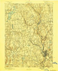
1893 Map of Waterbury
USGS Topo · Published 1898About this map
Industrial centers and small agricultural townships across the Litchfield and New Haven county line define this late nineteenth-century landscape. The Naugatuck River serves as the primary corridor for commerce and transport, carrying the Naugatuck Div. N.Y. N.H. & H. R.R. through manufacturing hubs like Thomaston and Waterville. In the southeast, the urban density of Waterbury contrasts with the surrounding uplands, where family-named landmarks like Latimer Hill and Town Plot Hill overlook the river valleys.
Find a feature on this map
94 named features on this map. Tap any name to fly to it.
Don’t see what you’re looking for? This feature index may not catch every label — zoom into the map to look around manually.
Map Details
Editions of this 1893 Waterbury Map
2 editions found
Other maps of this area

1889 · Derby
USGS Topo · 1:62,500

1891 · Derby
USGS Topo · 1:62,500

1892 · Winsted
USGS Topo · 1:62,500

1892 · New Haven
USGS Topo · 1:62,500

1892 · Danbury
USGS Topo · 1:62,500

1892 · Cornwall
USGS Topo · 1:62,500

1892 · New Milford
USGS Topo · 1:62,500

1892 · Meriden
USGS Topo · 1:62,500

1892 · Granby
USGS Topo · 1:62,500

1893 · Waterbury
USGS Topo · 1:62,500