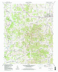
1994 Map of Watertown
USGS Topo · Published 1997About this map
Watertown serves as the primary hub of this Tennessee landscape, situated along Round Lick Creek and the Sparta Pike. The surrounding countryside is defined by a dense network of hollows and ridges, including Mt Defiance and Log Hollow, which dictate the winding paths of rural routes like Snerrilltown Road and Cainsville Road. Small rural communities and crossroads, such as Doaks Crossroads, Cherry Valley, and Sherrilltown, are scattered throughout the terrain, often centered on local institutions like Fall Creek Ch or the Norene Sch.
Find a feature on this map
68 named features on this map. Tap any name to fly to it.
Don’t see what you’re looking for? This feature index may not catch every label — zoom into the map to look around manually.
Map Details
Editions of this 1994 Watertown Map
This is the sole edition of this map. No revisions or reprints were ever made.
Other maps of this area

1908 · Woodbury
USGS Topo · 1:62,500

1916 · Murfreesboro
USGS Topo · 1:62,500

1942 · Statesville
USGS Topo · 1:100,000

1942 · Lebanon
USGS Topo · 1:100,000

1951 · Lebanon
USGS Topo · 1:24,000

1956 · Vine
USGS Topo · 1:24,000

1956 · Columbia
USGS Topo · 1:250,000

1956 · Nashville
USGS Topo · 1:250,000
1957 · Lascassas
USGS Topo · 1:24,000

1958 · New Middleton
USGS Topo · 1:24,000