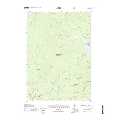
2018 Map of Waterville Valley
USGS Topo · Published 2018About this map
White Mountain National Forest dominates this mountain landscape, where the Mad River carves a deep valley between the peaks of the Sandwich Range and the towering Mt Osceola. The settlement of Waterville Valley serves as a modern focal point, connected to outlying points like Goose Hollow and the site of Tripoli Mill by a network of seasonal routes and trails. Evidence of earlier mountain life is preserved at the Mad River Cem and along the Old Waterville Road, while the terrain remains defined by high-altitude features like Dickey Notch and the Greeley Ponds. The map details a sophisticated recreational landscape, marking named paths such as the Boulder Path and Cascade Path that traverse the slopes of Mt Tecumseh and Noon Peak.
Find a feature on this map
76 named features on this map. Tap any name to fly to it.
Don’t see what you’re looking for? This feature index may not catch every label — zoom into the map to look around manually.
Map Details
Editions of this 2018 Waterville Valley Map
This is the sole edition of this map. No revisions or reprints were ever made.
Other maps of this area

1895 · Crawford Notch
USGS Topo · 1:62,500

1896 · Crawford Notch
USGS Topo · 1:62,500

1928 · Plymouth
USGS Topo · 1:62,500

1929 · Franconia
USGS Topo · 1:62,500

1931 · Plymouth
USGS Topo · 1:62,500

1931 · Mt. Chocorua
USGS Topo · 1:62,500

1932 · Franconia
USGS Topo · 1:62,500

1946 · Crawford Notch
USGS Topo · 1:62,500

1949 · Portland
USGS Topo · 1:250,000
1950 · Crawford Notch
USGS Topo · 1:62,500