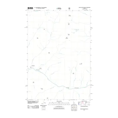
2011 Map of Waugh Mountain
USGS Topo · Published 2011About this map
The Salmon River carves a deep path through this Idaho County landscape, defining the topography south of Waugh Mountain. This 2011 survey documents a wilderness area characterized by high ridges and numerous creek drainages, including Phantom Creek, Eagle Creek, and Little Squaw Creek. Human presence is sparse, concentrated at the Lantz Bar Forest Service Facility and the remote Eakin Cabin. The terrain is marked by significant elevation changes, from the river bars like Lucky Creek Bar and Spindle Creek Bar to high points such as Lost Packer Peak. Names like Lost Packer Meadows and Fawn Ridge suggest a legacy of backcountry exploration and seasonal use. The intricate network of seasonal and perennial streams illustrates the complex drainage patterns feeding into the Salmon River corridor.
Find a feature on this map
37 named features on this map. Tap any name to fly to it.
Don’t see what you’re looking for? This feature index may not catch every label — zoom into the map to look around manually.
Map Details
Editions of this 2011 Waugh Mountain Map
This is the sole edition of this map. No revisions or reprints were ever made.
Other maps of this area

1956 · Elk City
USGS Topo · 1:250,000

1960 · Elk City
USGS Topo · 1:250,000

1962 · Wood Hump
USGS Topo · 1:24,000

1962 · Square Top
USGS Topo · 1:24,000

1962 · Butts Creek Point
USGS Topo · 1:24,000

1977 · Cottonwood Butte
USGS Topo · 1:24,000

1978 · Waugh Mountain
USGS Topo · 1:24,000

1978 · Dennis Mtn
USGS Topo · 1:24,000

1978 · Devils Teeth Rapids
USGS Topo · 1:24,000
1979 · Cold Meadows
USGS Topo · 1:24,000