
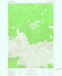
1962 Map of Square Top
USGS Topo · Published 1964About this map
The Salmon River cuts a deep canyon through the wilderness of central Idaho, serving as a boundary between the Bitterroot National Forest and the Salmon National Forest. This 1962 survey highlights a landscape dominated by steep drainage systems like Horse Creek, Gunbarrel Creek, and Wheat Creek. These waterways feed into the main river, where numerous Rapids are marked, including a crossing at Horse Creek Bridge.
Find a feature on this map
31 named features on this map. Tap any name to fly to it.
Don’t see what you’re looking for? This feature index may not catch every label — zoom into the map to look around manually.
Map Details
Editions of this 1962 Square Top Map
2 editions found
Other maps of this area

1956 · Elk City
USGS Topo · 1:250,000

1960 · Elk City
USGS Topo · 1:250,000

1962 · Wood Hump
USGS Topo · 1:24,000

1962 · Blue Joint
USGS Topo · 1:24,000

1962 · Long Tom Mtn
USGS Topo · 1:24,000

1962 · Horse Creek Butte
USGS Topo · 1:24,000

1962 · Butts Creek Point
USGS Topo · 1:24,000

1977 · Cottonwood Butte
USGS Topo · 1:24,000

1978 · Waugh Mountain
USGS Topo · 1:24,000
1979 · Stripe Mtn
USGS Topo · 1:24,000