
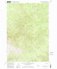
1962 Map of Horse Creek Butte
USGS Topo · Published 1964About this map
Gattin Ranch sits in a high drainage of the Salmon National Forest in this 1962 field-checked survey of Lemhi County. The terrain is defined by a dense network of high ridges and named creeks, including Oreana Ridge and Long Tom Ridge, which separate the various branches of Horse Creek. This mid-century study captures a remote interior landscape where human presence is marked primarily by scattered outposts such as Big Indian Camp and Swamp Camp. A lonely Jeep Trail provides the only recorded vehicle access toward the southwest, passing near the high-elevation Corn Lake. For the local historian or outdoorsman, the map preserves the exact locations of these remote stations and the specific nomenclature used by the Forest Service before modern wilderness designations further altered land management in the region.
Find a feature on this map
24 named features on this map. Tap any name to fly to it.
Don’t see what you’re looking for? This feature index may not catch every label — zoom into the map to look around manually.
Map Details
Editions of this 1962 Horse Creek Butte Map
2 editions found
Other maps of this area

1956 · Elk City
USGS Topo · 1:250,000

1960 · Elk City
USGS Topo · 1:250,000

1960 · Painted Rocks Lake
USGS Topo · 1:62,500

1960 · Shoup
USGS Topo · 1:62,500

1962 · Wood Hump
USGS Topo · 1:24,000

1962 · Blue Joint
USGS Topo · 1:24,000

1962 · Square Top
USGS Topo · 1:24,000

1962 · Long Tom Mtn
USGS Topo · 1:24,000

1962 · Butts Creek Point
USGS Topo · 1:24,000

1982 · Bighorn Crags
USGS Topo · 1:100,000