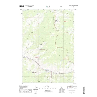
2020 Map of Waugh Mountain
USGS Topo · Published 2020About this map
Salmon River waters carve through a landscape defined by dramatic elevation changes where the borders of the Bitterroot National Forest, Payette National Forest, and Salmon National Forest converge. Along the river banks, small settlements like Lantz Bar, Lucky Creek Bar, and Spindle Creek Bar mark the few accessible flats in an otherwise vertical environment. These bars represent historical points of activity along the Salmon Wild and Scenic River corridor, often serving as critical river access points or former homestead sites. Higher elevations are dominated by landmarks such as Waugh Mtn, Elkhorn Mountain, and Lost Packer Peak. The map details a network of historic trails and service roads, including the Square Top-West Horse and the Shoup-Elk City routes, which navigate the high ridges and connect remote alpine features like Lost Packer Lake and Lost Packer Meadows.
Find a feature on this map
52 named features on this map. Tap any name to fly to it.
Don’t see what you’re looking for? This feature index may not catch every label — zoom into the map to look around manually.
Map Details
Editions of this 2020 Waugh Mountain Map
This is the sole edition of this map. No revisions or reprints were ever made.
Other maps of this area

1956 · Elk City
USGS Topo · 1:250,000

1960 · Elk City
USGS Topo · 1:250,000

1962 · Wood Hump
USGS Topo · 1:24,000

1962 · Square Top
USGS Topo · 1:24,000

1962 · Butts Creek Point
USGS Topo · 1:24,000

1977 · Cottonwood Butte
USGS Topo · 1:24,000

1978 · Waugh Mountain
USGS Topo · 1:24,000

1978 · Dennis Mtn
USGS Topo · 1:24,000

1978 · Devils Teeth Rapids
USGS Topo · 1:24,000
1979 · Cold Meadows
USGS Topo · 1:24,000