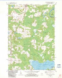
1982 Map of Wausaukee South
USGS Topo · Published 1983About this map
Wausaukee serves as the northern anchor for this Marinette County landscape, where the Escanaba and Lake Superior Railroad cuts a north-south line through a mosaic of wetlands and timber. The settlement pattern follows this rail corridor, connecting the small community of Middle Inlet and the descriptively named Sweetheart City. The topography is defined by the winding waters of the Menominee River along the Michigan-Wisconsin border and the expansive reach of Lake Noquebay in the south, which includes the Lake Noquebay State Public Hunting Grounds.
Find a feature on this map
68 named features on this map. Tap any name to fly to it.
Don’t see what you’re looking for? This feature index may not catch every label — zoom into the map to look around manually.
Map Details
Editions of this 1982 Wausaukee South Map
This is the sole edition of this map. No revisions or reprints were ever made.
Other maps of this area

1939 · Porterfield
USGS Topo · 1:48,000

1940 · Athelstane
USGS Topo · 1:48,000

1941 · Coleman
USGS Topo · 1:48,000

1942 · Athelstane
USGS Topo · 1:48,000

1942 · Coleman
USGS Topo · 1:48,000

1942 · Porterfield
USGS Topo · 1:48,000

1942 · Wausaukee
USGS Topo · 1:48,000

1947 · Wausaukee
USGS Topo · 1:48,000

1950 · Coleman
USGS Topo · 1:48,000

1954 · Iron Mountain
USGS Topo · 1:250,000