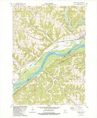
1983 Map of Wauzeka West
USGS Topo · Published 1983About this map
The confluence of the Kickapoo River and the Wisconsin River defines this riverine landscape in the early 1980s. The village of Wauzeka sits at this strategic junction, bordered by the steep rises of Wauzeka Ridge and the Lower Wisconsin River State Wildlife Area. This era shows a transition from historical industrial transport to modern conservation; while an Old Railroad Grade and the Wisconsin Western route track the lowlands, much of the floodplain is dedicated to wildlife management. Significant local landmarks include the Kickapoo Indian Caverns and several named ridges like Polander Ridge and Dutch Ridge, which reveal the upland settlement patterns of Crawford and Grant counties. Small community centers like Millville and the Townhall serve as anchor points for the surrounding rural hollows, including Campbell Hollow and Rhein Hollow Road.
Find a feature on this map
39 named features on this map. Tap any name to fly to it.
Don’t see what you’re looking for? This feature index may not catch every label — zoom into the map to look around manually.
Map Details
Editions of this 1983 Wauzeka West Map
This is the sole edition of this map. No revisions or reprints were ever made.
Other maps of this area

1900 · Lancaster
USGS Topo · 1:125,000

1902 · Elkader
USGS Topo · 1:125,000

1903 · Waukon
USGS Topo · 1:125,000

1904 · Lancaster
USGS Topo · 1:125,000

1908 · Lancaster
USGS Topo · 1:125,000

1926 · Wauzeka
USGS Topo · 1:62,500

1929 · Prairie Du Chien
USGS Topo · 1:62,500

1932 · Prairie Du Chien
USGS Topo · 1:62,500

1958 · La Crosse
USGS Topo · 1:250,000

1959 · Dubuque
USGS Topo · 1:250,000