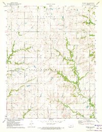
1971 Map of Waverly SE
USGS Topo · Published 1973About this map
Pottawatomie Creek and its many tributaries define the agricultural character of this eastern Kansas landscape along the border of Coffey and Anderson counties. The rural area is divided into historical townships such as Pottawatomie, Rock Creek, and Star, reflecting the early administrative patterns of the Great Plains. Settlement is sparse, anchored by the small community of Wells, while the presence of a Landing Strip and a modern Pipeline suggests the mid-century integration of traditional farming with new infrastructure. The terrain is marked by a dense network of watercourses including Rock Creek, Elm Creek, and Long Creek, which together create a complex drainage system across the prairie. This map provides a clear view of the rural homesteads and township lines as they existed in the early 1970s.
Find a feature on this map
13 named features on this map. Tap any name to fly to it.
Don’t see what you’re looking for? This feature index may not catch every label — zoom into the map to look around manually.
Map Details
Editions of this 1971 Waverly SE Map
This is the sole edition of this map. No revisions or reprints were ever made.
Other maps of this area

1885 · Burlington
USGS Topo · 1:125,000

1885 · Garnett
USGS Topo · 1:125,000

1894 · Garnett
USGS Topo · 1:125,000

1894 · Burlington
USGS Topo · 1:125,000

1947 · Lawrence
USGS Topo · 1:250,000

1950 · Lawrence
USGS Topo · 1:250,000

1956 · Williamsburg
USGS Topo · 1:24,000

1956 · Lawrence
USGS Topo · 1:250,000

1957 · Waverly NW
USGS Topo · 1:24,000

1957 · Waverly
USGS Topo · 1:24,000