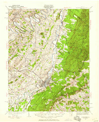
1934 Map of Waynesboro
USGS Topo · Published 1958About this map
Waynesboro serves as a vital junction in the Shenandoah Valley during the early 1930s, where the Chesapeake and Ohio and Norfolk and Western railroads intersect near the South River. The landscape transitions from the agrarian valley floor, dotted with local landmarks like the Augusta Military Academy at Port Defiance and the District Home, into the rising elevations of the Blue Ridge Mountains. Transportation engineering is prominently displayed through the Blue Ridge Tunnel and Brookville Tunnel at Afton, alongside the winding path of Skyline Drive as it begins to trace the ridge. Small communities such as Fishersville, New Hope, and Crimora anchor the rural districts, supported by a network of one-room schools like Middle Grove Sch and Burren Ridge Sch. Recreational and civic growth is visible in the presence of the Swannanoa Club and an early Landing Field, reflecting the area's development before the mid-century expansion.
Find a feature on this map
93 named features on this map. Tap any name to fly to it.
Don’t see what you’re looking for? This feature index may not catch every label — zoom into the map to look around manually.
Map Details
Editions of this 1934 Waynesboro Map
2 editions found
Other maps of this area

1892 · Buckingham
USGS Topo · 1:125,000

1892 · Harrisonburg
USGS Topo · 1:125,000

1894 · Staunton
USGS Topo · 1:125,000

1894 · Lexington
USGS Topo · 1:125,000

1929 · Covesville
USGS Topo · 1:62,500

1931 · University
USGS Topo · 1:62,500

1934 · Waynesboro
USGS Topo · 1:48,000

1935 · Covesville
USGS Topo · 1:62,500

1935 · University
USGS Topo · 1:62,500

1936 · Vesuvius
USGS Topo · 1:48,000