
1972 Map of Waynesboro East
USGS Topo · Published 1974About this map
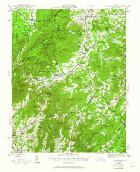
The city of Waynesboro sits at the foot of the Blue Ridge in this 1972 orthophotoquad, which utilizes aerial photography to reveal the precise textures of the Virginian landscape. The imagery captures a critical moment of expansion as the urban footprint of the city pushes eastward toward the rising slopes of the mountains. Beyond the developed streets, the photograph shows the intricate patchwork of agriculture and timber lots that once dominated the approaches to the gap.
Find a feature on this map
2 named features on this map. Tap any name to fly to it.
Don’t see what you’re looking for? This feature index may not catch every label — zoom into the map to look around manually.
Map Details
Editions of this 1972 Waynesboro East Map
This is the sole edition of this map. No revisions or reprints were ever made.
Other maps of this area

1892 · Buckingham
USGS Topo · 1:125,000

1892 · Harrisonburg
USGS Topo · 1:125,000

1929 · Covesville
USGS Topo · 1:62,500

1931 · University
USGS Topo · 1:62,500

1934 · Waynesboro
USGS Topo · 1:48,000

1935 · Covesville
USGS Topo · 1:62,500

1935 · University
USGS Topo · 1:62,500

1939 · Waynesboro
USGS Topo · 1:62,500
1943 · Lovingston
USGS Topo · 1:62,500

1945 · Covesville
USGS Topo · 1:62,500