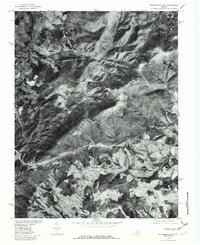
1977 Map of Waynesboro East
USGS Topo · Published 1982About this map
The eastern edges of Waynesboro and the high ridges of the Blue Ridge define this late 1970s orthophotoquad, which uses aerial photography to capture the landscape of Albemarle County. The image reveals the sharp contrast between the industrial and residential development of the city and the winding mountain corridors of Skyline Drive. Significant mountain passes like Rockfish Gap and Jarman Gap appear as critical transit points, while the drainage patterns of Stockton Creek and Sawmill Run carve through the forested slopes. Small settlements like Afton, Avon, and Newtown are visible along the valley floors, providing a clear view of the rural-to-urban transition during this era. The detailed photo base makes it possible to distinguish between dense woodland, open pastures, and early suburban expansion around the South River.
Find a feature on this map
13 named features on this map. Tap any name to fly to it.
Don’t see what you’re looking for? This feature index may not catch every label — zoom into the map to look around manually.
Map Details
Editions of this 1977 Waynesboro East Map
This is the sole edition of this map. No revisions or reprints were ever made.
Other maps of this area

1892 · Buckingham
USGS Topo · 1:125,000

1892 · Harrisonburg
USGS Topo · 1:125,000

1929 · Covesville
USGS Topo · 1:62,500

1931 · University
USGS Topo · 1:62,500

1934 · Waynesboro
USGS Topo · 1:48,000

1935 · Covesville
USGS Topo · 1:62,500

1935 · University
USGS Topo · 1:62,500

1939 · Waynesboro
USGS Topo · 1:62,500

1943 · Lovingston
USGS Topo · 1:62,500

1945 · Covesville
USGS Topo · 1:62,500