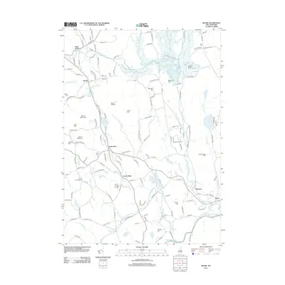
2012 Map of Weare
USGS Topo · Published 2012About this map
The Piscataquog River and its various branches, including the Middle Br Piscataquog River, define the hydrologic landscape of this part of Hillsborough County. The town of Weare serves as a central hub, surrounded by smaller settlements such as North Weare, South Weare, and Tavern Village. This area exhibits a pattern of rural New England development where early family and community burial grounds, like Quaker Cem and East Weare Cem, are dispersed among several significant hills, including Mount William and Mount Wallingford. The northern portion of the map is dominated by the Hopkinton Everett Flood Control Area, which includes Everett Lake and the settlement of Everett. To the east, residential and recreational areas cluster around Gorham Pond, while the former rail-oriented hamlet of Riverdale sits near the river in the southeast, providing a clear view of the region's historical transition from industry to a more quiet, suburban character.
Find a feature on this map
145 named features on this map. Tap any name to fly to it.
Don’t see what you’re looking for? This feature index may not catch every label — zoom into the map to look around manually.
Map Details
Editions of this 2012 Weare Map
This is the sole edition of this map. No revisions or reprints were ever made.
Other maps of this area

1900 · Peterboro
USGS Topo · 1:62,500

1906 · Milford
USGS Topo · 1:62,500

1926 · Hillsboro
USGS Topo · 1:62,500

1927 · Concord
USGS Topo · 1:62,500

1929 · Hillsboro
USGS Topo · 1:62,500

1943 · Fitchburg
USGS Topo · 1:125,000

1948 · Boston
USGS Topo · 1:250,000

1949 · Portland
USGS Topo · 1:250,000

1949 · Concord
USGS Topo · 1:62,500
1953 · Peterborough
USGS Topo · 1:62,500