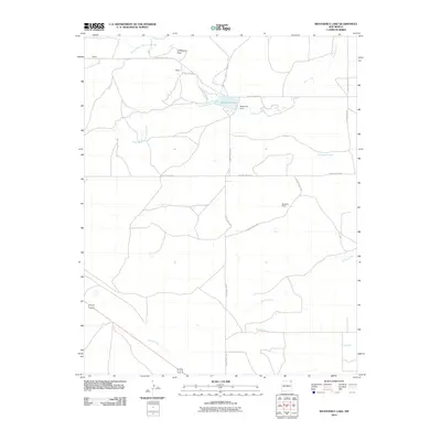
2010 Map of Weatherly Lake
USGS Topo · Published 2010About this map
Corrumpa Creek and its many tributaries, including South Branch Corrumpa Creek and North Branch Corrumpa Creek, define the water-carved landscape of this corner of Union County. The northeastern New Mexico ranching culture is anchored by landmarks like Weatherly Ranch and the nearby Weatherly Lake, created by Weatherly Dam. These water sources were vital for livestock and settlement in the high plains. Small named locales such as Hittson and Brown appear alongside a network of county roads, while the prominent Lonesome Rock provides a distinct navigational marker. To the south, US Route 64 87 skirts the drainage of Seneca Creek, showing the persistence of traditional transportation corridors through the open range.
Find a feature on this map
24 named features on this map. Tap any name to fly to it.
Don’t see what you’re looking for? This feature index may not catch every label — zoom into the map to look around manually.
Map Details
Editions of this 2010 Weatherly Lake Map
This is the sole edition of this map. No revisions or reprints were ever made.
Other maps of this area

1954 · Dalhart
USGS Topo · 1:250,000

1958 · Dalhart
USGS Topo · 1:250,000

1962 · Dalhart
USGS Topo · 1:250,000

1972 · Little Grande
USGS Topo · 1:24,000
1972 · Fiddler Springs
USGS Topo · 1:24,000

1972 · Cross L Ranch SW
USGS Topo · 1:24,000
1972 · Des Moines
USGS Topo · 1:24,000

1972 · Cow Mountain
USGS Topo · 1:24,000
1973 · Wetherly Lake
USGS Topo · 1:24,000

1973 · Grenville SW
USGS Topo · 1:24,000