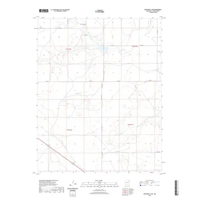
2020 Map of Weatherly Lake
USGS Topo · Published 2020About this map
Weatherly Lake and its surrounding drainage basin define the high plains geography of Union County in this modern topographic survey. The landscape is characterized by a complex network of seasonal watercourses, including the N Br Corrumpa Cr, S Br Corrumpa Cr, and the main stem of Corrumpa Cr. These arroyos carve through the plateau, providing critical water sources like Black Springs in an otherwise arid environment.
Find a feature on this map
23 named features on this map. Tap any name to fly to it.
Don’t see what you’re looking for? This feature index may not catch every label — zoom into the map to look around manually.
Map Details
Editions of this 2020 Weatherly Lake Map
This is the sole edition of this map. No revisions or reprints were ever made.
Other maps of this area

1954 · Dalhart
USGS Topo · 1:250,000

1958 · Dalhart
USGS Topo · 1:250,000

1962 · Dalhart
USGS Topo · 1:250,000

1972 · Little Grande
USGS Topo · 1:24,000
1972 · Fiddler Springs
USGS Topo · 1:24,000

1972 · Cross L Ranch SW
USGS Topo · 1:24,000
1972 · Des Moines
USGS Topo · 1:24,000

1972 · Cow Mountain
USGS Topo · 1:24,000
1973 · Wetherly Lake
USGS Topo · 1:24,000

1973 · Grenville SW
USGS Topo · 1:24,000